Saturday, July 23, 2016

Bare Peak Overlook (Nelson Ridge)

I went up Bare Peak Overlook on Tuesday, July 19th, and almost forgot to post this! I had actually planned on going to Bare Peak, but changed my mind last minute. Partly because I had gotten a late start in the day, and this is a mighty long drive from Missoula, and partly because I knew it would be a hot day, and my dog, Xena (or Z.Z., [XeXe] as I've recently taken to calling her) gets overheated quite quickly, and I can only bring so much water. If there had been more water on the trail, she could go forever! 
The drive there is WAAAAY up the West Fork. South of Darby, you take the West Fork up 14 miles to the Nez Perce turnoff. I wish I had written down the miles, but I didn't, and almost a week later, I can't remember what I did. There is, however, a sign that points you right up to the Nelson Lake Trailhead. I think the name was Nelson-Rimmel, or something like that. I'll fix this when I figure it out.  Anyway, the drive to the trailhead is about 5 miles from there. The problem is, the road keeps going a ways, so just remember, after you see the sign about halfway up this road to the trailhead, it's only about 2.3 miles to it. It's just around a switchback, and the only sign marking it is a "Put your fire out," sign....little tricky.
Ok, the hike: this one is short, just over 3 miles, but really steep almost the whole way. There is a fork in the trail about 1.5 miles up, but I didn't see it. I had started down toward the lake before I realized that couldn't be right. I turned around and headed back up to see a "kind of" fork. This is what it looked like:

The rock and tree across the trail you're supposed to take up is a dead give-away....I guess. If you miss this, you'll be heading to the right, and it's obvious you're starting down the mountain. As I got here and kept going up, I kind of lost the trail, mostly because of a little deadfall. If you stay close to the ridge line, it's no problem. I didn't realize till the way down that there is a pretty good trail the whole way. It seriously didn't make a difference. It was quite straight forward. 


First sighting of Nelson Lake


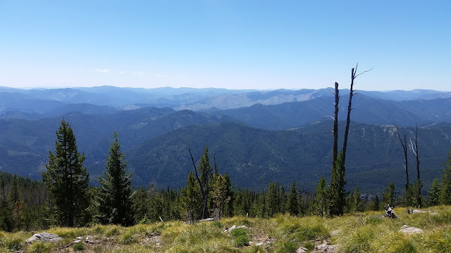
I believe that's Bare Peak in the distance


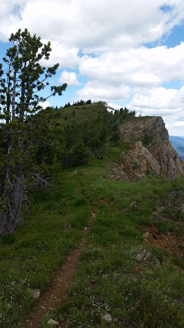
A small amount of rock scrambling on
the way back down


As I was coming back down, I thought, "I still have plenty of daylight left," so I decided to head down to the lake. I knew Xena would love it, she gets giddy around water. The more I climbed down, the more I dreaded the climb back up. It was probably close to another 2 miles to get down there, and I was not happy to see what was in front of me. The lake had a pretty steep bank all around it, as far as I could tell, and I had just decided I was done for the day. There really wasn't a trail anywhere around it, so I turned around, and much to Xena's chagrin, headed back up. 
About as close as I got to the lake
It was a beautiful day, and if I felt like I had more time, I would have investigated whether or not I could have gotten down there a little more. Oh, well, I hit a new summit, so I was quite satisfied either way. The hike up to Bare Peak Overlook was about 3 miles, with an elevation gain of 2558. 


Monday, July 18, 2016

Eagle Cliff

So, I finally got in a NEW summit this year, although, it was only a 7547 ft. peak.  That's ok, because it was new to me, and that's what I thrive on! It is 19 miles up Dry Creek Rd., just west of Superior. Actually, I think it's in Superior, but it's the next exit down, exit 43 from I-90. Take a left off the ramp (If you're coming from Missoula, as I was) and Dry Creek Rd. is on the right, not too far down the road.  Stay on it for 19 miles. I know that sounds like a lot, but it's probably the best mountain road I've ever driven on. I could have taken my Cadillac up here. (Oh, how I miss that car!) Here's the tricky part. You can't see the trailhead from this direction, unless you're looking backwards while driving. The best hint I can give you is that there is what looks like a gated road on the left that hasn't been driven in ages. I parked here. If you start walking back in the direction from which you came, you'll suddenly see the trail sign:


Unfortunately, on this day, the forest service had not gotten up here yet this year.  The first half mile was covered in newly downed trees. Getting around, or over them, was a test in patience and a little pain management! I had to keep talking myself into going just a little more, as the trail opened up a little more every giant bunch of dead trees.


I actually read in the paper the next day how there was a planned hike up here, and to call such-and-such a number to go on it. I called and let them know how difficult that first 1/2 mile was, and it was highly appreciated! The gentleman I spoke to said he would get those USFS horses up there to get it cleared out. Wow! I hope he has that kind of pull!
So, after that first half mile, it was easy going. It was a pretty gentle grade up, and, as always, quite lovely. Mountains as far as the eye could see! It was less than a three mile hike, with an altitude gain of 1252, from 6295 ft. to 7547 ft. As you can see, not a difficult day.


First glimpse of the lakes below

Larger, closer lake: Cliff Lake, smaller: Diamond Lake


Still some snow on July 14th!


You could only see Cliff Lake from the top of Eagle Cliff


Since I felt this was a pretty easy hike, and I had time left in my day, I decided to drive down to the lakes and see how they looked up close.  It's about a 9.6 mile drive to the turn off to the lakes, then 4 miles in from there. I highly recommend it. They are just beautiful! And Cliff Lake, the longest part of that hike, was only one mile in. Although, I will say, it was quite popular. I rarely bump into people mid-week (this was a Thursday) and there were 5 or 6 cars in the parking area. They all stayed at Diamond Lake, so we had Cliff Lake to ourselves.

Daimond Lake:


The hike between Diamond Lake and Cliff Lake just had the largest meadow of more different flowers than I think I've ever seen in one place. The pictures don't do it justice!


Looking back towards Diamond Lake


Update! The gentleman I spoke with e-mailed me two days later and said they had cleared that first half mile of trail, and the hikers that went had a great hike! So, this should be a great hike for anyone now! YAY!